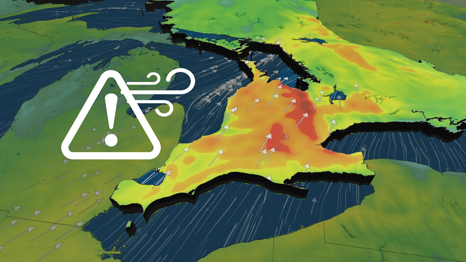
Strong winds and warmth rush into southern Ontario
The first significant melt will begin across southern Ontario to start this week, with above-seasonal temperatures and strong winds replenishing the warmth
Much of Canada is slowly emerging from the February deep freeze, with noticeably warmer temperatures spanning the country to start out this final week of the month.
Gusty winds will help to usher in the above-seasonal conditions across southern Ontario for Monday, with rain and possibly snow returning by the mid-week mark. With the rise in temperatures, the concern over flooding in some locales increases with the snowmelt.
DON'T MISS: Risk of flooding as temperatures rise in southern Ontario
Toronto's Pearson airport has only reported a total of 3.1 mm of rain so far this winter, well below the normal of the 57.7 mm that typically falls.
Across the Greater Toronto Area (GTA), it'll be a close call between the rain and snow through Thursday, with much of eastern Ontario seeing the better chances for snowy impacts late week.
Monday and Tuesday: Winds and warmth spread across southern Ontario
A system tracking north will open the door for mild temperatures to start off this week in southern Ontario.
DON'T MISS: Ready for a tease of spring? Thaw to spread across Canada
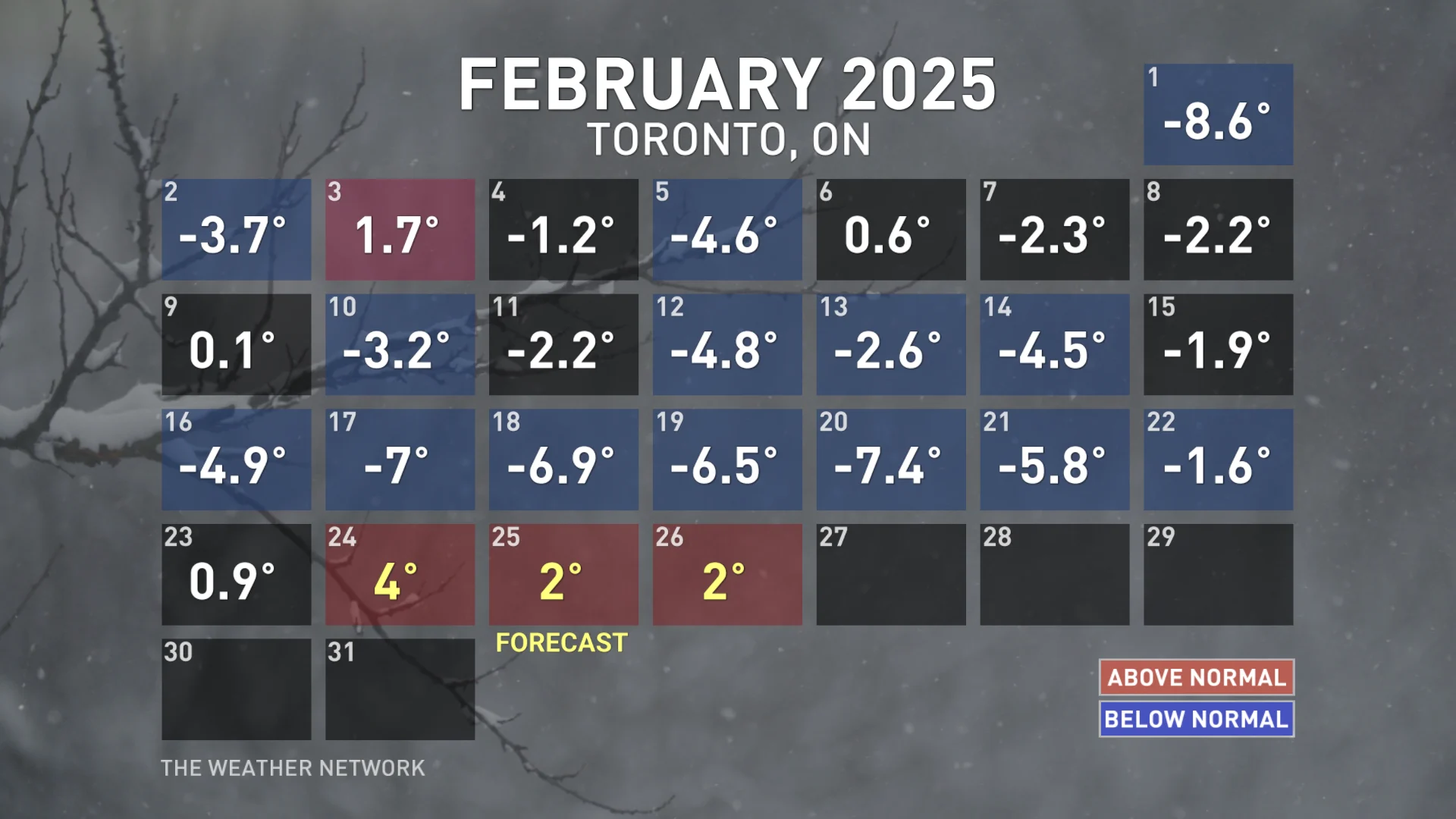
Monday and Tuesday both hold the potential for the warmest daytime highs of the year so far, with temperatures set to hit around 4°C in Toronto. The normal for this time of year is closer to 1°C.
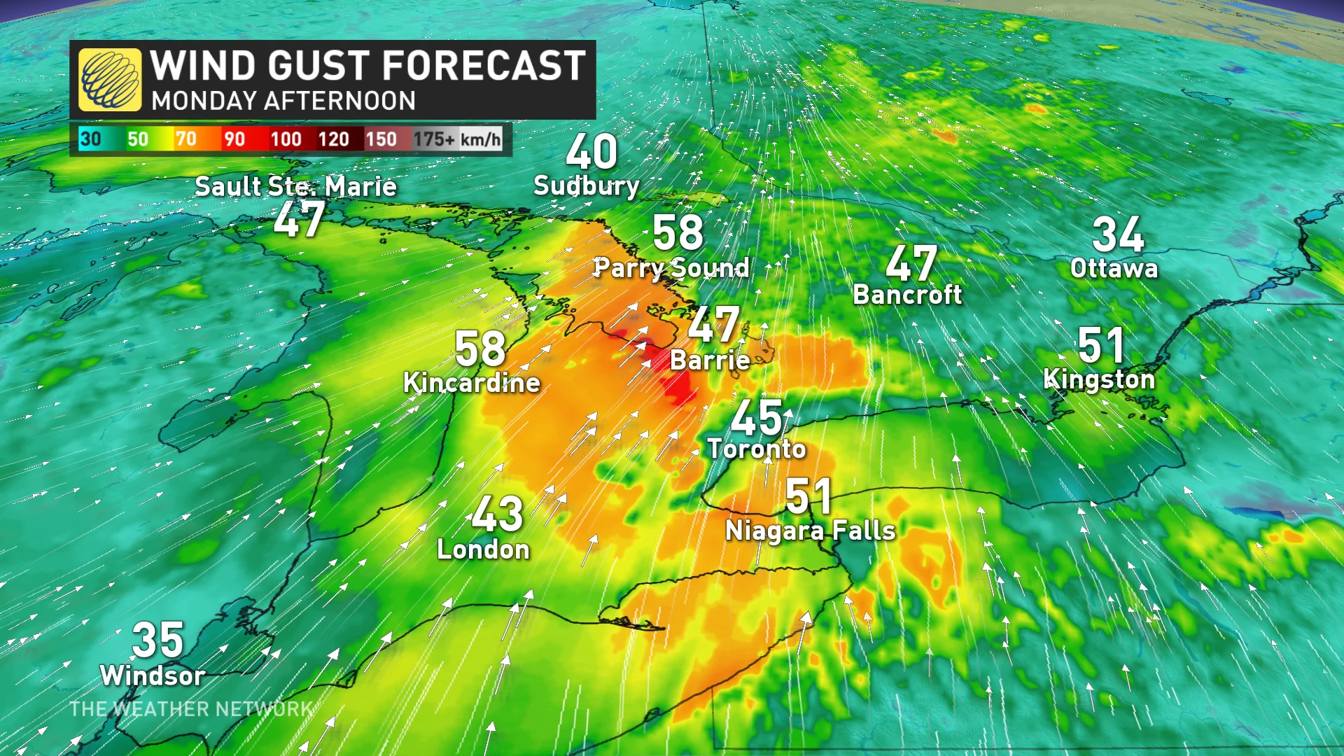
The milder temperatures Monday will be paired with strong winds, however, with gusts reaching between 70-90 km/h through the afternoon.
The gustiest winds can be expected along the escarpment before easing during the evening hours. Residents should prepare in case of power outages.
By Tuesday, the rain chances begin to move in, though it'll be a hit and miss kind of day. Regardless, the recent daunting snow piles and snowpack will begin to melt.
Wednesday and Thursday: Rain and snow chances increase, but temperatures will play a role
A low-pressure system will track in late Wednesday afternoon across southwestern Ontario, reaching the GTA by evening, and Ottawa Thursday morning.
RELATED: Great Lakes have the most ice in years amid prolonged cold spell
Across the southwest, Lake Erie shorelines and through the Niagara region, rainfall will be the favoured precipitation type, while those to the north will see some wet, heavy snow in the 5-10 cm range.
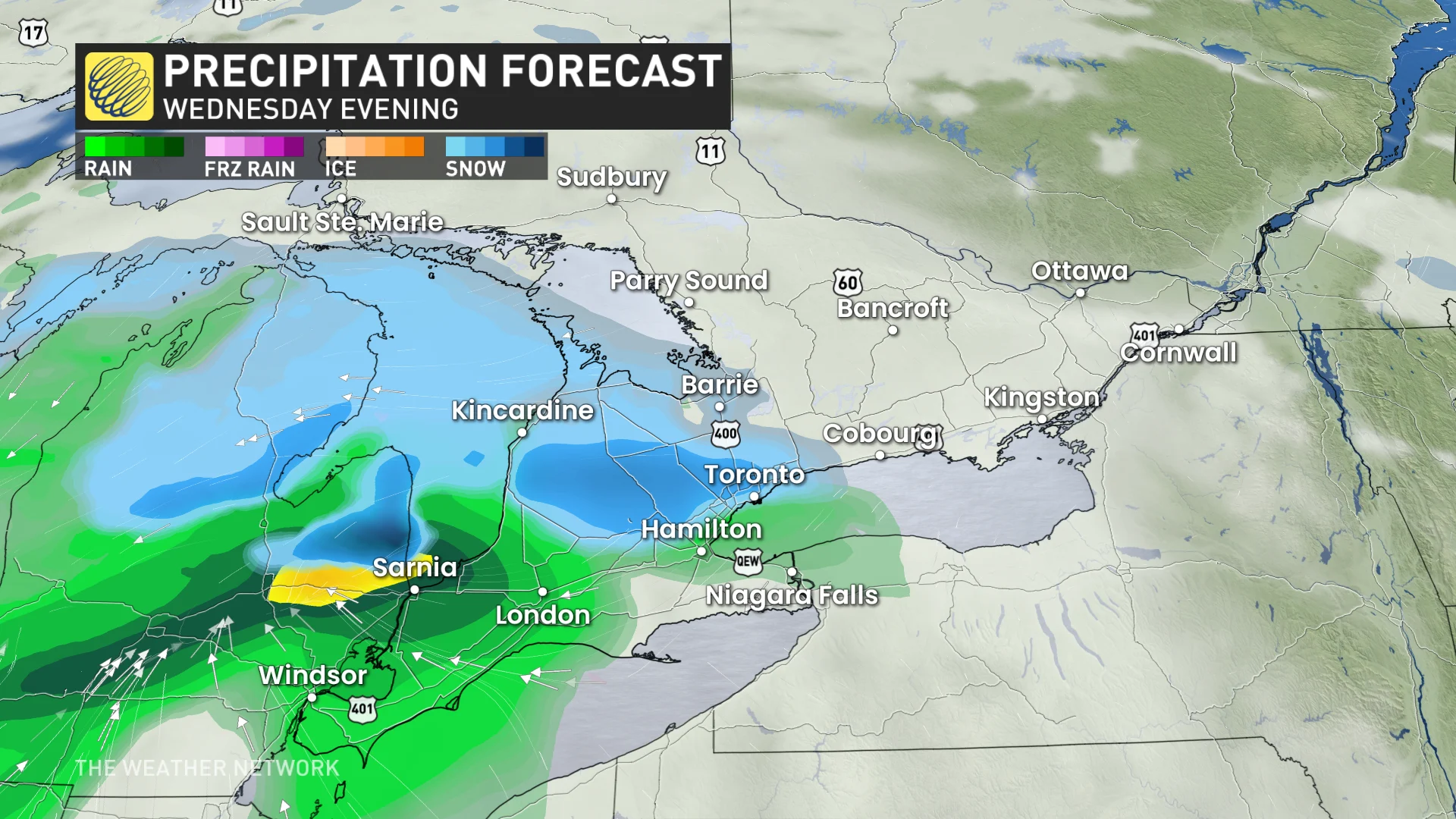
The GTA is toeing the rain and snow line, with precipitation likely starting as snow and changing over to rain early Thursday along the Lake Ontario shoreline.
A snowy commute can be expected across eastern Ontario and the Ottawa area Thursday morning.
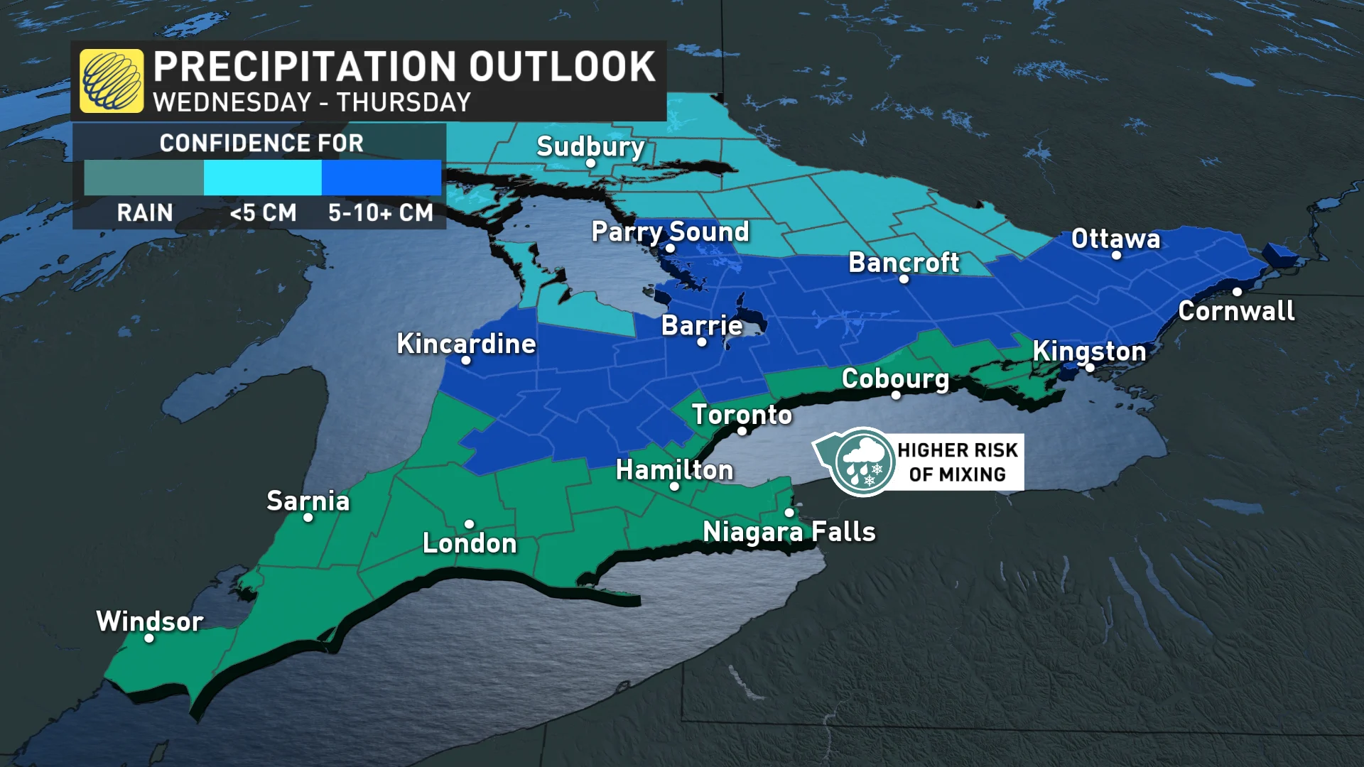
There is still some uncertainty with the rain and snow totals, as the storm track and small temperature change could make a large difference.
Winter's not finished, yet: Cold weather returns as we kick off March
Colder weather is expected to return for the weekend, with a more wintry pattern likely to dominate for the first 10-15 days of March. Temperatures will be changeable, but overall colder than normal.
DON’T MISS: La Niña’s last hurrah? Pattern could disappear by this spring
Also, we will have a jet stream pattern that will bring a heightened risk for winter storms, but it is too early to have confidence in the exact storm track, as it could stay south and east of the region.
Be sure to check back for the latest weather updates across Ontario.