Growing severe thunderstorm risk takes the stage in Ontario
A Colorado low could trigger a major severe weather outbreak across the U.S. on Wednesday, with some of the severe weather possibly spilling into Ontario overnight.
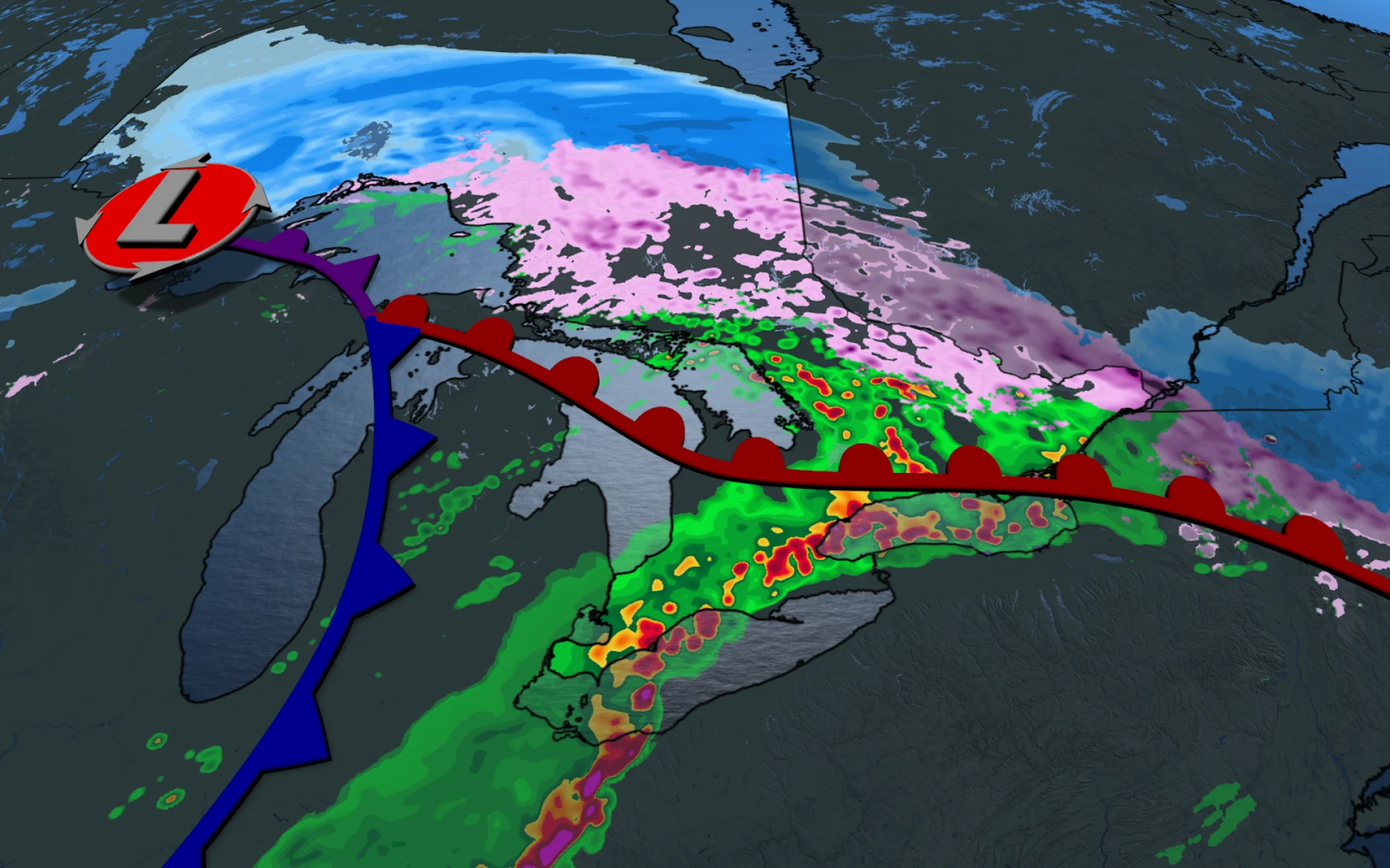
A Colorado low tracking through the Great Lakes region has brought the whole spectrum of active weather to Ontario on Wednesday. Freezing rain and snow fell over areas where more than 150,000 customers remain without power from this past weekend’s ice storm. Ice pellets, snow, and even thundersnow was reported across the Golden Horseshoe as well.
Gusting winds in combination with locally heavy snowfall led to low visibility on major highways. Highway 6, north of the 403, was closed on Wednesday due to the snowy, slippery conditions that led to reports of sliding transports and pinned vehicles.
Photos: Ontario ice storm causes widespread damage, outages
The ice and snow moved out of the Golden Horseshoe area Wednesday afternoon but will remain as an evening and overnight risk through eastern Ontario, including the Ottawa region.
Taking the main stage, however, will be the overnight thunderstorm threat in southern Ontario, leading to an increased localized flood threat.
Nighttime severe storm threat builds in the southwest
A cold front sliding in from the west will start to move into southwestern Ontario through Wednesday evening and the early overnight hours, leading to a risk for thunderstorms across the area. Some of these storms could turn severe, especially close to the Michigan border.

Cold waters in the lakes themselves will reduce the severity of any storms that have to cross the lakes, leaving the greatest risk for severe storms in extreme southwestern Ontario around Windsor, Leamington, Chatham, and up into Sarnia.
The system will be convective in nature, with the greatest chance of seeing a lightning show after sunset.
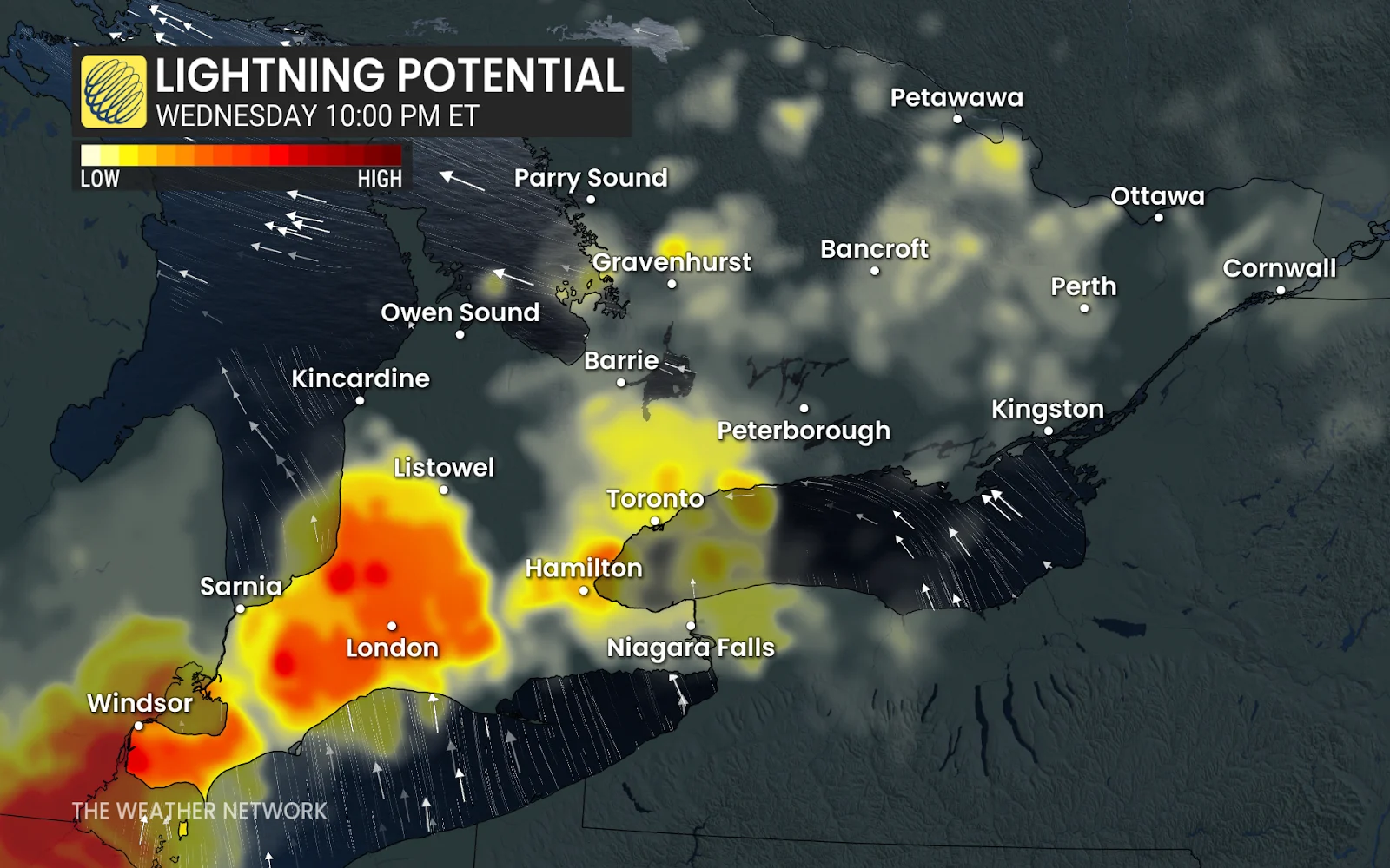
The winds will change from northeasterly to southerly in the evening, and strong wind gusts could reach 50-70 km/h, and even up to 80 km/h in exposed shoreline regions.
Strong wind gusts and heavy rainfall are the predominant threats with the strongest thunderstorms. It’s worth noting there’s a small, conditional threat for tornadoes if enough energy is able to move into southwestern Ontario from Michigan.

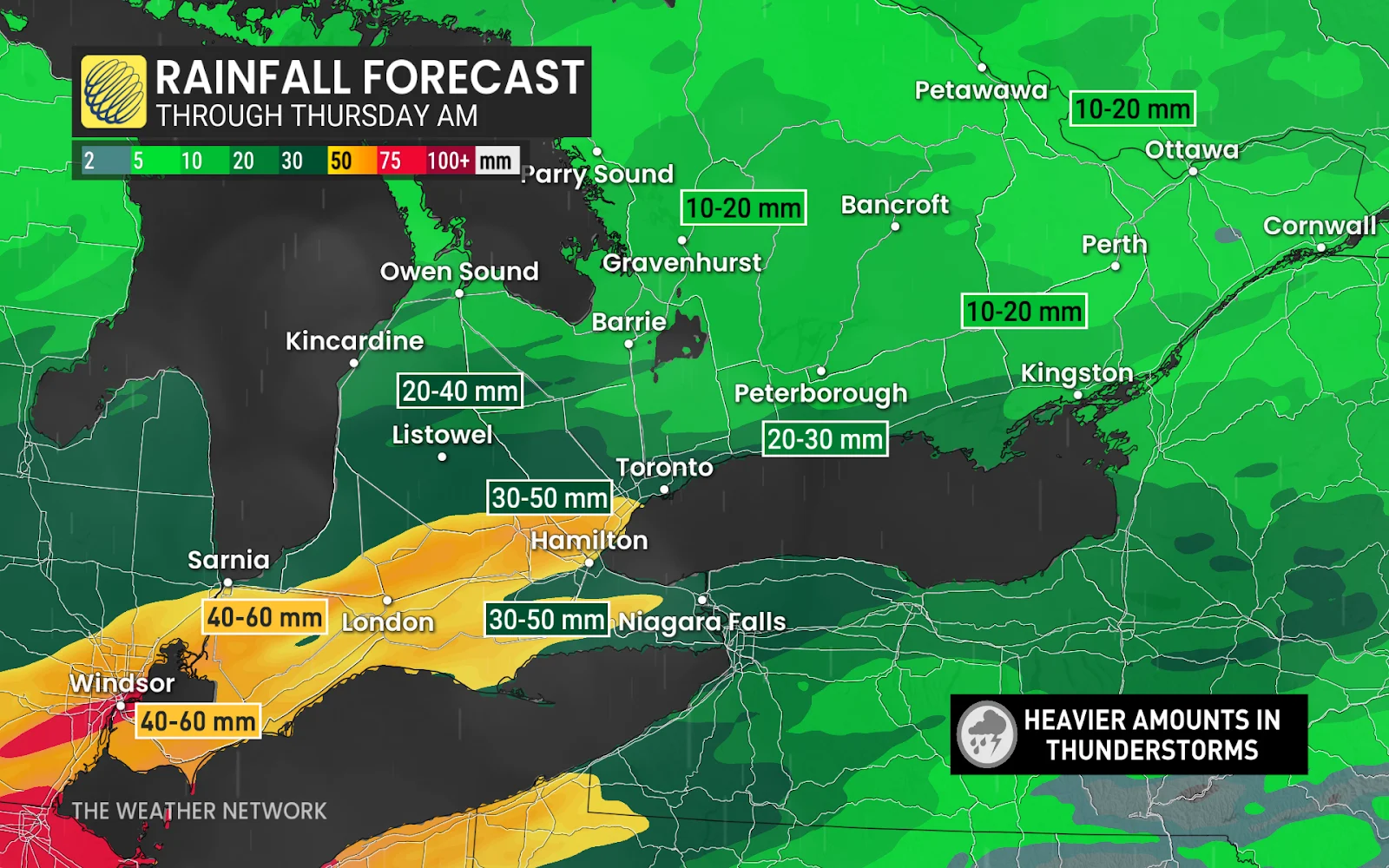
30-60 mm of heavy rains are forecast where we will see the strongest of the storms develop--from Windsor to Hamilton.
Looking into Thursday, once the system has left the province, we'll see a significant warmup that will leave people feeling dizzy from the sharp change.
90,000,000+ at risk south of the border
Ontario’s thunderstorm risk arrives on the very northern end of a widespread severe thunderstorm outbreak expected across the United States on Wednesday.
The potential for severe weather covers nearly 100,000,000 people south of the border, with dangerous thunderstorms possible from central Texas all the way north into western New York. Expect dangerous highway travel and disrupted airline travel throughout many major hubs.
The strongest U.S. thunderstorms are capable of producing 120+ km/h wind gusts, hail the size of golf balls or larger, and tornadoes.
RELATED: How supercells grow to produce giant hail and intense tornadoes
A full-blown tornado outbreak is possible for some regions. The U.S. Storm Prediction Center (SPC) issued a high risk for severe weather—a level five out of five—for portions of the Mid-South, including the city of Memphis, Tennessee.
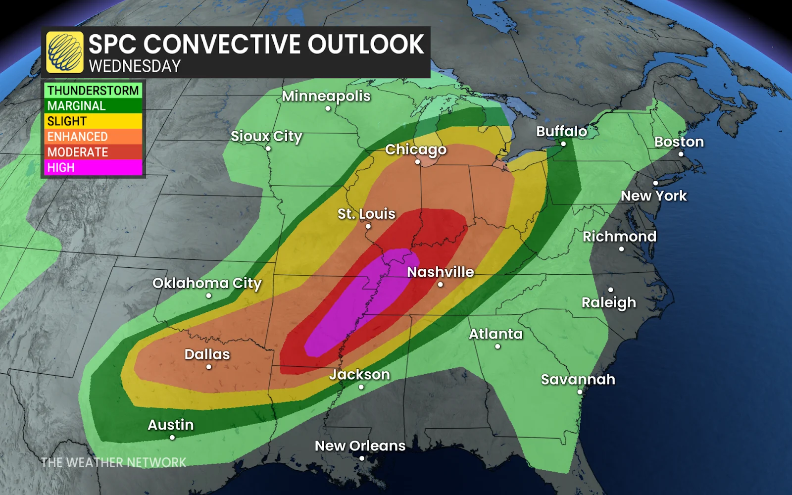
“Numerous tornadoes, along with multiple long-track EF3+ tornadoes appear likely” across the high-risk areas, the SPC said in its overnight forecast.
U.S. forecasters reserve issuing a high risk for severe weather for days they’re extremely confident in a tornado outbreak. On average, the SPC only issues one or two high risks per year—and sometimes entire years pass between severe weather setups that warrant such a forecast. Wednesday is only the 67th high-risk day in the U.S. since Jan. 1, 2000.
A major flooding threat will develop through the weekend across many of the same areas expecting significant storms on Wednesday. The U.S. Weather Prediction Center (WPC) warned that “a prolonged life-threatening flash flood event will begin today with several days of heavy rainfall impacting a large portion of the Lower Mississippi and Ohio valleys.”